Bill and Deanne at Canyon Lake
The smoke is rising from the restaurant in the town of Tortilla Flat, population...6.
It would perhaps surprise most folks to see how much water there is in this part of Arizona. Many of the creeks are flowing this time of year.
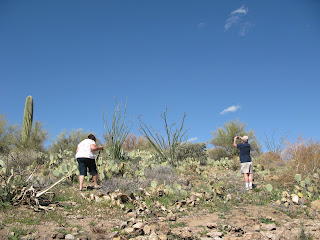
I'm having mixed feelings about Rich having a camera but here is a shot he took of me and Bill climbing up to take photos of a flowering ocotillo cactus. Yeah, I know, I really should wear shoes instead of flips when trekking up desert hillsides.
The next two photos were taken from a spot called Fish Creek Hill. The drive to there is gnarly, but then there is a paved walkway to the edge of a canyon. It is not possible to capture the heights and colors and depths and layers and distances that we often see, but we continue to record and share the best that we shoot hoping to convey at least some sense of the magnificent scenery throughout our beautiful country.
After we left Fish Creek Hill, we drove down the roads you see in this photo.
Our next stop was just past the one lane bridge over Fish Creek at the bottom of this deep narrow rock canyon. The next two photos are an attempt to show scale: Rich is standing in the road we just came through while taking a picture and in the other there is a rock climber hiking to his climb (look left from the center, he is wearing a gray shirt with black sleeves and is standing behind green shrubs; very tiny figure).
Continuing our gorgeous and thrilling drive...
...a perfect poppy and Apache Lake (see Rich taking photos way down there, bottom left?).
Only a short portion of the Apache Trail road runs alongside the Salt River. The river connects the three lakes on this drive but runs through the mountains and valleys; it cannot be seen from the road except along here.
Approaching Roosevelt Lake from Apache Junction, you first see the dam then continue driving up to an overlook between the dam and the bridge.
It was extremely windy there on Monday; the guys couldn't even keep their hats on.
The bridge over Roosevelt Lake.
Roosevelt Lake and the gathering clouds.
Our next stop was at the Tonto National Monument. We opted to not walk up to the cliff dwellings so these shots were taken from the parking lot. The closeup shows some of the structures at the entrance of this nineteen room cliff dwelling constructed and occupied by the Salado Indians from about 1300 A.D.
You can see the curved roof of the cave near the top of the hill toward the left.
By then we had reached paved highway again, the clouds rolled in, and we watched rain in the distance all the way to Globe where it finally caught up with us. That put an end to any decent photography for the day.
Lovin' Life ~~ And Another Perfect Scenic Drive


No comments:
Post a Comment
Please leave a comment, I love reading them!